PHOTO
Eugowra residents are invited to a public information session to talk through the draft Flood Study Review, which is currently on exhibition for community comment.
Cabonne Council has engaged consultants to prepare the review - with a local committee and based on local information - and they will be at the meeting at Eugowra's Multipurpose Centre from 6-8pm on Monday, 2 February to answer any questions residents have.
The purpose of the Flood Study Review is to define the impact that flooding has on the urbanised parts of Eugowra for a range of flood events, and has used updated flood modelling, calibrated with data from the catastrophic 2022 event, along with community feedback.
The next step is to develop a flood risk management study and plan for the township.
The aim of the Flood Risk Management Study and Plan is to help the council refine plans for mitigating and managing the effects of existing flood risk (associated with existing development on flood prone land), future flood risk (associated with any new development on flood prone land) and continuing flood risk (the risk remaining in both existing and future development areas after floodplain risk management measures are implemented).
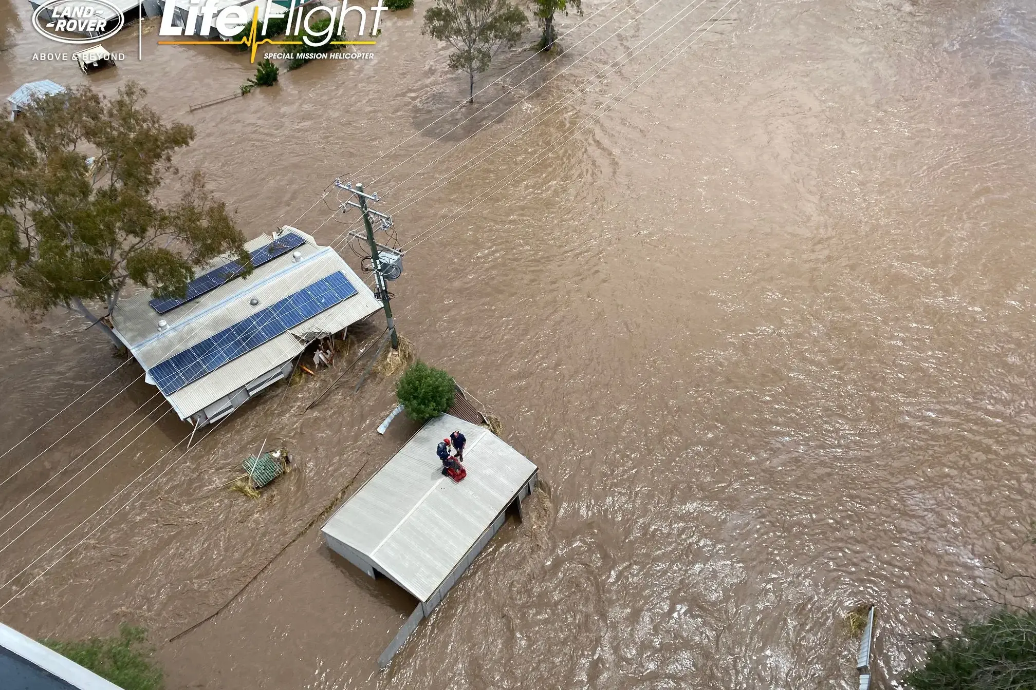
The new review looks at what was unprecedented about the tragic November 2022 flood, which resulted in the loss of two local lives.
"The flooding that was experienced in Eugowra on the morning of 14 November 2022 was unprecedented in terms of the historic post-settlement flood record in that it not only inundated land that lies along the Western Floodway, but it also inundated land that lies along the Eastern Floodway as far east as Noble Street," the draft report says.
"Peak flood levels at Eugowra were up to about 1.5 m higher than those that were experienced at the time of the August 1990 and April 1950 floods.
"The November 2022 flood was unique in that it was associated with a band of fast-moving intense rain which moved across the catchment from west to east in about one hour, resulting in high rates of flow being experienced in both Mandagery Creek and Boree Creek (both of which are of similar size and shape upstream of their confluence) almost simultaneously, with the result that the rate of flow in the main arm of Mandagery Creek almost doubled downstream of their confluence.
"The short-duration but intense nature of the storm also resulted in a rapid response time of the catchment which in turn resulted in a rapid increase in the rate of flow (and hence water levels) in not only the main arm of Mandagery Creek, but also the various watercourses which drain to it."
The new review does include three new rating curves for the upstream gauge, which reflect the different conditions depending on crops.
There are models for no mature crops (representative of the August 1990 flood); for mature wheat crops on the Smithfield paddocks (representing the conditions of the November 2005 and November 2022 floods); and for mature wheat crops on both Smithfield and Redbank paddocks (as in December 2010).
The report is available at the post office, or on the council's website at cabonne.nsw.gov.au
Comments and submissions may be lodged in writing to the General Manager, PO Box 17, Molong NSW 2866 or by emailing council@cabonne.nsw.gov.au by 5pm on Thursday, 19 February 2026.